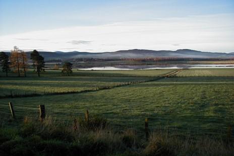
The Tarland Burn Catchment (~70 km2) has been studied since the year 2000 making it one of the longest running comprehensive catchment management case studies in the UK. Critically there has been core funding support through cycles of Scottish Government strategic research programmes in turn, enabling integration with UK and European projects.
As, the uppermost tributary of the River Dee, (NE Scotland) and under intensive land management, the Tarland Catchment has several pressures associated with diffuse pollution, alteration of river morphology, flood risk and a rural community with a high proportion of private septic tanks. This makes the Tarland Catchment a particularly interesting case study and for over 20 years, regular routine spatial monitoring and experimental studies have been combined to investigate water quality, habitat quality and biodiversity, diffuse pollution impacts and flood mitigation.
Stage
Directory of Expertise
Purpose
The Tarland Catchment has a history of flooding causing damage to property, infrastructure and agricultural land and is recognized by the Scottish Environmental Protection Agency (SEPA) as a community within a Potentially Vulnerable Area (PVA) for flooding. In addition, the water quality across the catchment has suffered from the effects of point (e.g., septic tanks overflows, farmyard run off) and diffuse (e.g., agricultural landscape) pollution.
To improve water quality and mitigate the effects of flooding, significant work has been carried out on the ground, providing an opportunity for empirical evidence to be collected and used to determine how effective different measures are and what additional benefits they have provided. Much of the work in the landscape was initiated or developed as part of the 3 Dee Vision (2003-2006) and Aquarius (2009-2012) projects supported by European funding which was made available to help to bring about the effective co-ordination of water environment policy and regulation across Europe. At Tarland, the several significant interventions installed in the landscape range from the planting of buffers strips to the creation of storage ponds and wetlands.
The aim of our research has been to improve water quality and the riparian habitat as well as to demonstrate Natural Flood Management (NFM) techniques that will help to mitigate local flooding. The Tarland catchment has been our ‘living lab’ of the landscape, ecology, and people, enabling us to test real issues; from experiments where we can isolate factors up to their inherent complexity as a whole catchment system.
In anticipation of the Tarland catchment works and prior to their commencement, monitoring sites for hydrology, water quality, and aquatic and terrestrial biodiversity were established. This allows a comparison of data pre- and post-intervention and continues to allow the effects of these actions, and subsequent actions, to be assessed.

Map showing the location of monitoring sites in the Tarland Catchment, and the subcatchment, upstream of Coull Bridge (Site 1).
Results
Flooding
In recent years (2000 onwards) the Tarland Burn has over topped its banks, flooding properties and roads in Tarland village on at least six occasions. Hydrological data from the Coull Bridge station (catchment area: 52 km2) has been used to improve flood model scenarios, relevant to the assessment of flood risk from extreme storm events. Most notably, these were storms on the 30th December 2015 and 7th January 2016, when water levels reached the highest recorded during the monitoring period (2000-current) at over 3 m at the Coull Bridge station.

Tarland - Burnside Road 7th Jan 2016 (Justin Irvine, James Hutton Institute)
Observations of water storage in a field runoff temporary-storage bund, (pictured below), near Tarland village, during this period showed it was filled five times due to the intense saturation of upstream soils. This highlights the limited water storage capacity of soils and Natural Flood Management (NFM) features during winter flood periods. Hence, there is a need to upscale the number of such NFM features at the catchment scale to minimize downstream flooding.

Overland flow disconnection bund in 2013 (Mark Wilkinson, James Hutton Institute)
Biodiversity
The introduction of buffer strips (pictured below) along riparian margins can help to mitigate the effects of diffuse pollution from farmed and developed land. This has an impact on water quality as well as having the potential to improve both terrestrial and aquatic biodiversity. Within the Tarland Catchment over 30% of the total stream length has been buffered since 2012, with one tributary unbuffered providing an experimental control site.

Buffer strip examples from the Tarland Catchment (James Hutton Institute archive)
Our research has shown that soil and vegetation characteristics, and how the buffer strips are designed (e.g. width) and managed, are key to determining how benefical they are for beetles that live on the ground. Longer-term monitoring, from 2000 to 2012, showed that the aquatic invertebrates were slow to respond but by 2012 there were indications of improving water quality measured using Biological Monitoring Working Party (BMWP) scores. This method uses aquatic invertebrates as biological indicators. Some are relatively tolerant to pollution, for example worms, and others thrive in cleaner water for example mayflies and stoneflies. However, this is may be due to a combination of catchment-scale changes that occurred at the same time rather than characteristics of the buffer strips. The aquatic invertebrates are more likely to be affected by factors influencing water quality directly such as pollution sources, as well as by the terrestrial habitat at the riparian edge which will influence things like shading, water temperature, food sources.
Water Quality
Water quality is one of the key aspects affecting aquatic biodiversity and has been measured at the catchment outlet, Coull Bridge, since 2001. One parameter of particular interest in this study is Phosporus (P) because when it enters the aquatic system it can cause nutrient enrichment and have detrimental effects on the ecology of the system. There are many potential P sources within the catchment for example, agricultural fertilisers, septic tanks, and sewage treatment works.
The long- term P (Total Dissolved Phosphorus (TDP) and Soluble Reactive Phosphorus (SRP)) concentrations found over the time series at Coull Bridge are shown in the figure below.

Pre-2010 the P concentrations were relatively stable, however, since 2010 a steady rise in TDP has been observed with a sharper peak (~0.18 mgTDP/L) in 2017 that subsequently decreased over a steadily rising baseline. Concentrations of SRP have also risen exceeding the Water Framework Directive good status threshold for annual average SRP (0.05 mgP/L). This is of concern as it indicates rising levels of nutrient enrichment in the aquatic environment which is likely to have detrimental effects on the ecology.
Sediment, is also a source of P. The way in which sediment moves through the system is complex. Within river systems it is possible to identify zones of deposition where P rich sediments are likely to settle. Active erosion sources, delivering sediment into the system can also be identified. Sediment sources can be mobilized at differing water levels which makes the transfer and supply in the system dynamic. These complex relationships have been investigated, working alongside a European group, leading to the publication of a research paper. Such data and insight is very unique and well beyond that available from the national WFD surveillance monitoring. In practical terms understanding sediment dynamics within the system can inform us how best to manage issues like bed siltation whilst minimizing the risk of releasing soluble P from the stored sediment P causing increased nutrient loads.
Pollutants such as P may come from a variety of sources, both point (e.g., septic tanks overflows) and diffuse (e.g., farmed land). There are perceived difficulties in locating and managing pollution across wider landscape areas (diffuse sources), relative to the management of known discrete point sources which makes understanding the relative contribution from sources important. When wastewater treatment works (WWTW) effluents at Tarland were studied recently alongside other WWTW inputs into dominantly rural watercourses, Tarland WWTW was found to discharge concentrated effluent periodically into the stream. This raised concentrations of nutrient and microbial parameters in the water column and toxic metals in the sediment but effects were local and not observable above background levels within half a kilometer. This suggested localised point source pollution impacts occurred alongside a range of complex rural diffuse source inputs within the 1 km transect length.
We are fortunate, in the Tarland catchment, to be able to directly measure many of the complex factors that affect the water quality, ecology and water quantity within the system. With combined monitoring over decades and short-term studies we have gained significant knowledge as to how these factors are related and how best to manage our land and water resources to reduce pollution, mitigate flood risk and improve our aquatic ecology.
Acknowledgements:
We would like to thank local landowners and managers and the wider Tarland community for allowing access to sites and supporting our research over many years.
We also fully acknowledge the efforts of Hutton colleagues, past and present, who have contributed to the collection and analysis of samples creating the existing +20 year time series of data.
Benefits
The Tarland monitoring site now provides us with both historic, a 20+ year time series of data, and current data from a multiscale nested catchment. The research data we’re collecting can be used to inform and help to reconcile policy requirements and land management decisions, in order that statutory requirements and the needs of the local communities can be met.
With respect to flood management, there have been multiple changes in approach over the last 100 years, the legacy of which can be clearly seen in Tarland (land drainage, heavily engineered systems and flood defences). The main policy driver now is the Flood Risk Management Act (Scotland) 2009 which suggests that NFM approaches; the alteration, enhancement, restoration or utilisation of natural landscape features should be considered when planning a flood scheme. Since 2000, this has involved the creation of a wetland with added capacity to retain flood flows, the temporary storage field bund and buffer strips as examples of NFM at Tarland. The continuation of the monitoring that was established prior to any groundworks now forms the basis of a particularly useful NFM case study site.
The research also gives a good footing on which to react to new demands for knowledge associated with sustainable (carbon-friendly) farming systems and a growing demand for opportunity assessment for river restoration projects across the River Dee.
Long term hydrological and water quality datasets are increasingly used in order to place the results of short term or experimental studies in context. Sample archives also offer opportunities for further investigation as new issues arise. For example, in recent years projects to study emerging contaminants such as personal care products, antibiotics and microplastics in the soil and water environment, (including pre, during and post the covid pandemic), have been carried out in the Tarland and wider Dee catchment.
Project Partners
MacRobert Trust
Aberdeenshire Council
Dee Catchment Partnership
Scottish Water