The way we manage land and plan land-use change plays an integral role in the efforts for meeting climatic targets and for mitigating and adapting to climate change impacts. According to the current Land Use Strategy, the scale of future land-use change required is significant if we were to maximise the contribution of land towards a sustainable future for Scotland. Therefore, decisions about land-use change need to be fully integrated and joined-up across sectors and scales and consider multiple objectives, e.g., changes in land-use would need to be optimised to reduce greenhouse gas (GHG) emissions alongside meeting other environmental goals.
Emerging geospatial technologies have led to a rapid increase in the volume of data being captured and processed and have enabled a step-change in global capacity for integrated monitoring, analysis, modelling, and visualisation of the natural environment at potentially transformative spatial and temporal scales. Spatially referenced data and digital maps can provide the reliable information needed to inform land-use planning across scales and support the evolution towards evidence-based policy making in the land and agricultural sectors in Scotland. The following case study summarises work delivered as part of a SEFARI Fellowship with Scottish Government’s (SG) Rural & Environment Science & Analytical Services (RESAS) to explore how spatial datasets can be used to support the evolution of land-based policy.
Stage
Directory of Expertise
Purpose
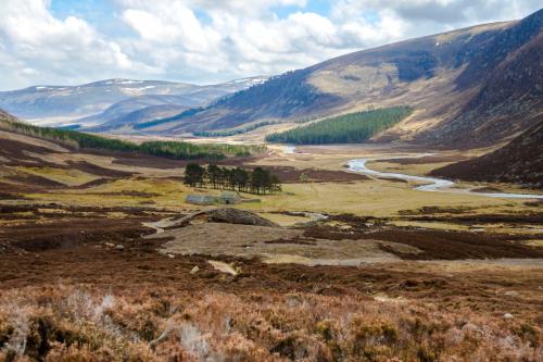
Land-use change, such as peatland restoration and woodland expansion (Figure 1), has been recognised as a significant element of a holistic strategy to deliver the Scottish Government’s challenging climatic target of net zero GHG emissions by 2045. Moreover, a post-Covid-19 green recovery, based on aligning green finance measures with climate objectives, depends greatly on the capacity of Scotland’s natural capital assets to deliver multiple environmental benefits.
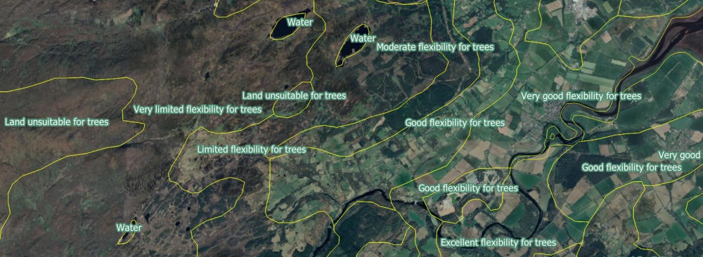 Figure 1: Example of a digital map: polygons of Land Capability for Forestry (LCF) classes showing the potential for land to grow trees based on a number of factors including soil, climate and topography.
In this complex and fast evolving policy landscape, there is increasing need for reliable information on the extent and condition of land systems to support policy formulation and evaluation of policy options and their impacts (both in time and space). Advances in spatial and other emerging digital technologies have led to a rapid increase in the volume of data being captured, curated, and processed. Innovative approaches combining Earth Observation (EO) technologies, machine learning (ML) models and cloud-based artificial intelligence (AI) platforms offer new capabilities for mapping and monitoring land resources and environmental change.
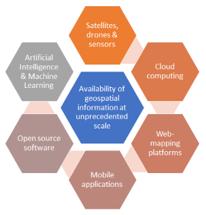
Figure 2: Digital ecosystem of technologies for capturing and processing geospatial information.
In this context, this SEFARI Gateway funded Fellowship with RESAS had two main objectives:
- A data-driven objective demonstrating how spatial datasets, such as digital maps, can be used to support land-related policy in Scotland. We used the Regional Land Use Partnerships (RLUPs) as our exemplar, whose function is to optimize the role land plays in meeting the legally binding targets for climate change emissions reduction in Scotland.
- A strategic objective assessing how spatial and other emerging digital technologies can be used to support the development of digital integrated systems for environmental and land-use statistics in Scotland, such as ERAMPP in Wales.
Results
Working with colleagues from RESAS and wider SG, we developed two web (R Shiny) apps that were designed to support RLUPs with decisions for planning land-use change, such as helping them with identifying opportunities for appropriate nature-based solutions, such as tree planting and peatland restoration.
We used spatial datasets related to land resources in Scotland from various sources that are stored in the Scottish Government’s spatial data portal to develop: a) a Spatial Data Catalogue app that provides filtering of more than 100 spatial layers using harmonised information organised in a consistent set of fields (e.g., land cover or habitat type) and b) a Spatial Visualisation app that provides an interface for viewing one or more digital maps (e.g., of habitats, land-use or soils), and for producing coverage statistics within RLUP boundaries for single maps or for map combinations. We also translated land type and habitat information stored in the digital maps to ecological indicators to enhance app functionality in assessing the delivery of ecosystem services from different land types, along with their associated environmental benefits.
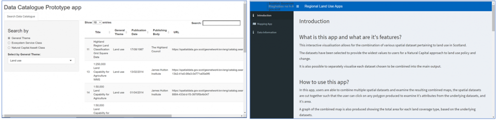
Figure 3: Screenshots of the Spatial Data Catalogue and Map Visualisation apps (Developers: Dave Cook and Mehdi Walji, Fast Stream Statisticians/RESAS)
In addition, in our strategic piece of work, we reviewed modelling and monitoring programmes that are currently operational in England and Wales. The review found that there is an increased interest in using spatial technologies for generating new dynamic digital land and environmental maps for various applications, such as supplementing data collection activities for building environmental baselines and for developing spatially-enabled modelling platforms designed to run scenarios of land-use change to inform decision and policy making.
Benefits
Our study highlighted the opportunities arising from spatial and other digital technologies for assessing, analysing, monitoring, and modelling the state of the natural environment. For this purpose, findings from the RLUPs and strategic pieces of work were synthesized to produce a set of recommendations to the SG on how spatial data and technologies can support the development of digital data approaches that are designed to integrate and analyse complex evidence to inform policy making for climate change adaptation, farming and food security and sustainable rural development in Scotland. For example, we suggested how spatial technologies can support a national environmental census to establish a baseline of the extent and condition of terrestrial ecosystems in Scotland, against which progress towards environmental targets and goals can be measured to determine whether the environment is improving, static or deteriorating further. We also suggested combining existing large-scale land type maps with new data collected from EO analysis and surveying to produce a single, dynamic, national Land-Use map of high spatial and temporal resolution, and highlighted the benefits of this approach for the generation of reliable land-use statistics needed for targeted policy making. Overall, our study showed that there is a clear potential of using spatial technologies to provide data-driven support in developing, testing, implementing, and evaluating policy options and their impacts on the environment and on rural communities, and in this way support the transition towards evidence-based policy making in the land and agricultural sectors in Scotland.
Project Partners
Scottish Government’s Rural & Environment Science & Analytical Services (RESAS)