Healthy, intact floodplains play an important role in mitigating extremes of water availability (droughts and floods) expected under climate change. Compared to other ecosystems, intact floodplains also support a disproportionately high biodiversity.
Floodplains often become detached from adjacent water courses by flood embankments resulting in a loss of these characteristics and reconnection through removing embankments can help to regain lost functions in river corridors. However, case studies of the effects on floodplain water levels and plant ecology remain rare.
Stage
Directory of Expertise
Purpose
The composition of floodplain vegetation communities is strongly influenced by the frequency and duration of flooding. Impacts of such a change on the vegetation however is poorly understood with the potential to significantly change a number of conditions necessary for plants to thrive and perform multiple functions. With an increase in waterlogging, nutrient deposition and seed dispersal caused by restoration, vegetation communities could therefore be significantly impacted causing a shift in composition.
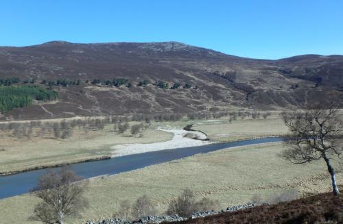
In October 2015, a 70m long historical embankment was deliberately lowered on the upper River Dee in Aberdeenshire, improving the links between the River Dee and the Allanmore floodplain. Since 2013 the floodplain has been monitored to assess the resulting changes. The 160-hectare floodplain consists of wet grassland and base poor (i.e., nutrient deficient) fen, important habitats for wader birds. Currently the floodplain is unmanaged but historical flood embankments, and drainage ditches, as well as more recent ditch blocking to improve wader habitat, affect the floodplain water levels and area of flooding.
This research study monitored a combination of the floodplain water table levels, river channel shape, and floodplain vegetation changes. Such monitoring could help to improve understanding of the rates and styles of responses to floodplain restoration needed to inform other projects in future.
Results
Earlier work covering the period from 2013 to 2018, showed the improved frequency of spillage of river water onto the floodplain (Addy and Wilkinson, 2018; Addy and Wilkinson, 2021). This reflects the lowering of the embankment and shallowing of the river channel that together reduced the flow level at which river water connects with the floodplain. Much of the change in river channel shape can be attributed to multiple large flood events in winter 2015/2016.
In this latest research study, the average annual duration and frequency of floodplain inundation (i.e., water levels above the ground level) have remained high following restoration due to improved connectivity between the river and the floodplain (Figure 1).

Figure 1 Record of floodplain water table level relative to ground level from one of three sensors (ML2) located 220 m from the river.
Prior to restoration the annual duration of flooding on the floodplain was 11 hours per year compared to 100 hours post restoration, a nine-fold increase. Moreover, median water table levels were on average 4 to 9 cm higher than before restoration again reflecting the improved connectivity.
Sustainability of the restoration, in terms of maintaining the flooding function post-restoration, has been good. The maintenance of the connectivity between the river and floodplain reflects the incidence of high flows especially during winter months and the lack of change in the surveyed channel. Since restoration, the floodplain has been regularly flooded likely resulting in the attenuation of moderate floods but not the very largest events (e.g., 1 in 200 year ‘Storm Frank’ flood event of 30th December 2015). The average annual frequency of floodplain inundation events was once per year before restoration and increased to 11 per year following restoration.
The identification of plant species in the 17 plots distributed across the floodplain (Figure 2) showed the number (richness) of plant species varied between plots (Figure 3). The highest numbers in 2021 were recorded close to the reconnection site (Plots 5, 6 and 8) where Sheep Fescue (Festuca ovina), common bent (Agrostis capillaris) and viviaparous sheep’s fescue (Festuca vivipara) grasses dominated. The lowest numbers were recorded in low lying areas further into the floodplain that are prone to deeper water during floods (Plots 10, 13 and 16) where rushes (Juncus species) and purple moor-grass (Molinia caerulea) occurred. No clear direction of change in the number of plant species between 2016 and 2021 was observed but comparison was affected by burial from sediment deposited by ‘Storm Frank’ in 2015 in four of the plots (Figure 3).

Figure 2 Vegetation Plot 7 in summer 2021 situated close to the lowered flood embankment and the river Dee. Vegetation in this plot was dominated by common bent (Agrostis capillaris) grass.

Figure 3 Number of vascular plants in 2016 and 2021 recorded in seventeen 2 by 2 m plots distributed in the Allanmore floodplain. Asterisks indicate plots that were partly obscured by sand deposits in 2016 thus affecting plant identification.
Benefits
In 2015 following restoration and the subsequent floods, the improvement in floodplain connectivity occurred quickly (within 3 months), highlighting the role of ‘letting the river do the work’ in restoring rivers and their floodplains. The increased frequency and duration of water being stored on the floodplain could have several benefits including attenuating small floods and improving river baseflows during droughts. Seven years after restoration, the improved connection between the river and its floodplain remains intact thus these potential benefits are likely to be sustained in the long term.
It is difficult at this stage to assess the effects of the increased wetting of the floodplain on vegetation. Even small changes in water table levels, and soil wetness, could result in significant changes in vegetation communities but no such changes have been observed on the Allanmore floodplain so far. Under climate change, increased winter flooding and summer droughts are predicted, and management activities such as changes to drainage ditches, grazing by deer and sheep or additional restoration could also have an impact.
Further work is required to link the changing hydrological character of the reconnected floodplain to the changes in vegetation community composition over time. Such knowledge is critical in understanding and predicting the vegetation responses to floodplain restoration projects in future.
Project Partners
Acknowledgements:
This research was funded by the Rural and Environmental Science and Analytical Services (RESAS) Division of the Scottish Government. We are grateful to Mar Lodge Estate (National Trust for Scotland), Invercauld Estate and Mar Estate for site access. The reconnection groundwork was funded by the EU Life project ‘Pearls in Peril’. The Dee Catchment Partnership initiated and coordinated the reconnection project.